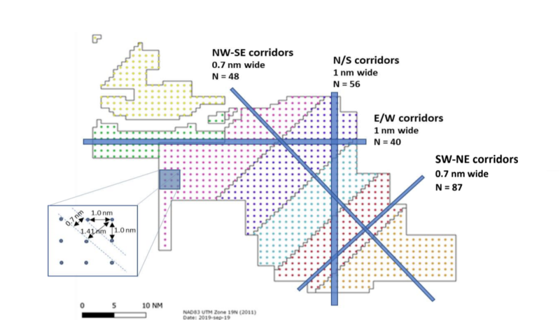
Five offshore wind energy developers are proposing a uniform plan to space turbines 1 nautical mile apart across the ocean off southern New England, contending the grid system will provide adequate safety for fishing vessels.
The companies – Vineyard Wind, Equinor, Ørsted, Eversource Energy and Mayflower Wind – say building turbines in rows oriented north to south and east to west will allow for safe passage through seven lease areas “without the need for additional designated transit lanes” and “provide a uniform, wide spacing among structures to facilitate search and rescue operations.”
Earlier traffic safety measures considered by the Coast Guard and federal Bureau of Offshore Energy Management have looked at wide vessel transit lanes through wind areas, including the New England areas off Martha’s Vineyard, and a 5-mile wide corridor across the New York Bight between Cape May, N.J., and Montauk, N.Y.
The wind companies publicly released their proposal Tuesday morning. Northeast sea scallop fishermen swiftly said they will not support it.
“Simply put, we were not consulted on this proposal, have not supported this proposal in the past, and do not support it now,” the industry group Fisheries Survival Fund said in a prepared statement.
“One nautical mile spacing between turbines neither allows for safe transit nor viable fishing, at least from the scallop fishery’s perspective,” the group said.
The developers’ first layout plans alarmed New England fishing groups, who saw the companies’ preferences for different turbine arrangements presenting an uneven obstacle course for crews trying to transit the arrays, particularly in bad weather.
In their proposal, the wind companies said meetings with Rhode Island and Massachusetts fisheries advisors, NMFS and others led to their proposal for uniform design, orientation along cardinal compass points, and at least one-mile spacing that “would provide each of these requested design elements, precisely as requested by the fishing industry.”
Another fishing industry group, the Responsible Offshore Development Alliance, said it will wait to see what the Coast Guard study group reports.
“After a series of workshops regarding the need for transit corridors in the New England lease areas, our membership was united in supporting the Coast Guard's efforts to evaluate navigational safety through its MARIPARS study, which is scheduled for release shortly,” according to a statement from the alliance. “Any project layout must be supported by evidence that the pattern minimizes risk to fishing and scientific survey vessel operators based on analyses of radar interference, insurance limitations, operability of search and rescue operations, and related factors.”
“We look forward to the results of those ongoing studies and a transparent discussion of their outcomes.”
In both industry meetings and in public commentary New England fishermen urged at least one-mile spacing between towers, the wind companies noted. But in some public sessions representatives for surf clam and ocean quahog operators have insisted they need two-mile spacing between the turbine towers to safely maneuver their vessels and heavy hydraulic dredges.
As part of their submission to the Coast Guard the wind companies commissioned a study by vessel and port safety consultants J.W. Baird and Associates Ltd. to evaluate the effectiveness of their layout plan. Baird analyzed Automatic Identification System (AIS) vessel tracking data from 2017 and 2018 to examine historic vessel tracks in the wind energy areas and consider the one-mile layout plan in light of international vessel safety guidelines.
Among its conclusion the Baird study says vessels up to 400 feet long could operate with the proposed one-mile turbine grid layouts. Most traffic through the wind areas now are fishing vessels on various routes, while most other commercial traffic transits around or on the edge of the planned wind energy areas, the companies say.


